Post by Andrei Tchentchik on Mar 4, 2020 15:55:19 GMT 2
(.#A.065).- Fires, heatwave and drought, how to explain the situation in Australia.
Fires, heatwave and drought: how to explain the unprecedented situation in Australia?
By: Damien Altendorf, scientific writer
January 5, 2020, 12:26 p.m.

Satellite view of fires in the Clyde Moutain region on December 31, 2019.
Credits: Sentinel-2A.

Fire, drought and exceptional heat continue on the Australian continent at the beginning of January 2020. This is even when the country has just known its hottest and driest year ever recorded. Indeed, 2019 has broken numerous records. Particularly from September to December, months during which the situation degenerated. In this article, we present some keys to better understand the unique situation in Australia.

Gigantic incendiary plumes, vast continental expanses caught in smoke, destruction of habitats and protected areas, etc. The images and figures bear witness to the seriousness of the situation and have been driving international news for several months now. A news that can offend sensitivity, even fuel a certain indignation.
Summary :
A consequence of climate change?
The Indian Ocean dipole in a very positive phase
Record destabilization of the Antarctic vortex
A consequence of climate change?
Also, there is a great temptation to draw a direct parallel to global warming and to see it as a brutal manifestation of the climate emergency. A pitfall to be wary of because, on the scale of such an extreme, most of the explanation lies in the low frequency meteorological configuration. "Low frequency" means a large-scale organization of the atmosphere over time constants ranging roughly from month to season.
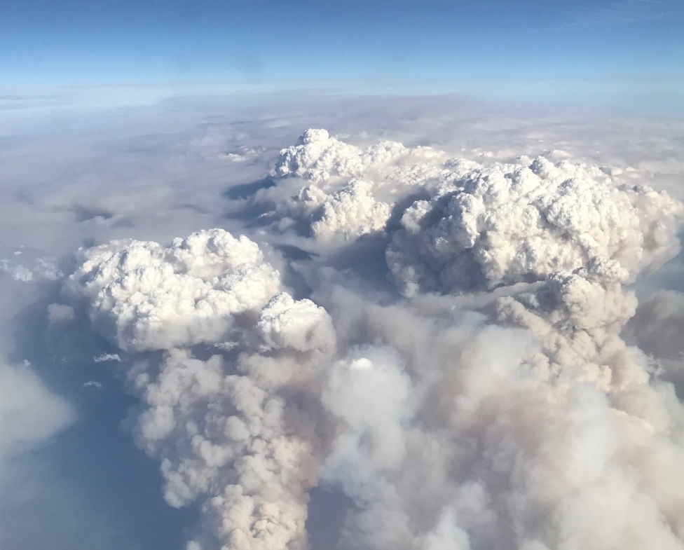
Aerial view of Australian smoke plumes (here associated with pyro-cumulus).
Credits: @merxplat.
In this perspective, climate change comes as an aggravating factor which increases the risk of the presence of heat waves, droughts or extreme fires. Read the 4th IPCC report for more details on this subject. Let’s move on to the presentation of the two meteorological factors considered to be decisive in the appearance of the extreme mentioned.
The Indian Ocean dipole in a very positive phase
One is a mode of natural variability in Indian Ocean temperatures: IOD (English acronym for Indian Ocean Dipole). Since winter 2019, the IOD has shifted to a marked positive phase. The latter is expressed by abnormally high sea surface temperatures (SST) to the west of the basin and abnormally low to the east.
Schematic representation of a positive phase of IOD.
Credits: BOM.
However, hot anomalies are associated with excess rain and cold anomalies are associated with excess drought. In other words, Australia has come under the influence of a large-scale subsistence movement that is very unfavorable to the establishment of a rainy regime.
Record destabilization of the Antarctic vortex
The other factor is a very brutal destabilization of the southern stratospheric vortex last September. Each year, this vortex eventually disappears as the spring sun warms the pole more and more. However, spring 2019 experienced an explosive destructuring. Which then spread to the surface, causing disruption of atmospheric circulation across the southern hemisphere.
Pressure anomaly as a function of altitude (ordinate axis) and time of year (abscissa axis) in 2019. Note the propagation towards the surface of the destructuring of the southern polar vortex (vast red / orange range between September and December).
Credits: NOAA / GDAS-CPC.
More specifically, a high pressure recurrence has settled on Antarctica while a low pressure belt has consolidated further north than usual. In particular, a low pressure lobe has taken hold in the southern Indian Ocean, favoring westerly to northwestern winds over Australian territory. Such winds move the overheated air from the desert to the southern and southeastern coastal fringes. In a previous context of rain deficit due to IOD, the overheating was increased and the temperatures soared. Added to the sensitive wind, the fires were able to give heart to joy.
For the moment, the situation is not expected to improve frankly. Several hot and dry lifts are still expected in the areas already afflicted by the events of the past few weeks. The weather villainous wave is therefore not yet over. Case to follow.
F I N .
Fires, heatwave and drought: how to explain the unprecedented situation in Australia?
By: Damien Altendorf, scientific writer
January 5, 2020, 12:26 p.m.

Satellite view of fires in the Clyde Moutain region on December 31, 2019.
Credits: Sentinel-2A.

Fire, drought and exceptional heat continue on the Australian continent at the beginning of January 2020. This is even when the country has just known its hottest and driest year ever recorded. Indeed, 2019 has broken numerous records. Particularly from September to December, months during which the situation degenerated. In this article, we present some keys to better understand the unique situation in Australia.

Gigantic incendiary plumes, vast continental expanses caught in smoke, destruction of habitats and protected areas, etc. The images and figures bear witness to the seriousness of the situation and have been driving international news for several months now. A news that can offend sensitivity, even fuel a certain indignation.
Summary :
A consequence of climate change?
The Indian Ocean dipole in a very positive phase
Record destabilization of the Antarctic vortex
A consequence of climate change?
Also, there is a great temptation to draw a direct parallel to global warming and to see it as a brutal manifestation of the climate emergency. A pitfall to be wary of because, on the scale of such an extreme, most of the explanation lies in the low frequency meteorological configuration. "Low frequency" means a large-scale organization of the atmosphere over time constants ranging roughly from month to season.
Aerial view of Australian smoke plumes (here associated with pyro-cumulus).
Credits: @merxplat.
In this perspective, climate change comes as an aggravating factor which increases the risk of the presence of heat waves, droughts or extreme fires. Read the 4th IPCC report for more details on this subject. Let’s move on to the presentation of the two meteorological factors considered to be decisive in the appearance of the extreme mentioned.
The Indian Ocean dipole in a very positive phase
One is a mode of natural variability in Indian Ocean temperatures: IOD (English acronym for Indian Ocean Dipole). Since winter 2019, the IOD has shifted to a marked positive phase. The latter is expressed by abnormally high sea surface temperatures (SST) to the west of the basin and abnormally low to the east.
Schematic representation of a positive phase of IOD.
Credits: BOM.
However, hot anomalies are associated with excess rain and cold anomalies are associated with excess drought. In other words, Australia has come under the influence of a large-scale subsistence movement that is very unfavorable to the establishment of a rainy regime.
Record destabilization of the Antarctic vortex
The other factor is a very brutal destabilization of the southern stratospheric vortex last September. Each year, this vortex eventually disappears as the spring sun warms the pole more and more. However, spring 2019 experienced an explosive destructuring. Which then spread to the surface, causing disruption of atmospheric circulation across the southern hemisphere.
Pressure anomaly as a function of altitude (ordinate axis) and time of year (abscissa axis) in 2019. Note the propagation towards the surface of the destructuring of the southern polar vortex (vast red / orange range between September and December).
Credits: NOAA / GDAS-CPC.
More specifically, a high pressure recurrence has settled on Antarctica while a low pressure belt has consolidated further north than usual. In particular, a low pressure lobe has taken hold in the southern Indian Ocean, favoring westerly to northwestern winds over Australian territory. Such winds move the overheated air from the desert to the southern and southeastern coastal fringes. In a previous context of rain deficit due to IOD, the overheating was increased and the temperatures soared. Added to the sensitive wind, the fires were able to give heart to joy.
For the moment, the situation is not expected to improve frankly. Several hot and dry lifts are still expected in the areas already afflicted by the events of the past few weeks. The weather villainous wave is therefore not yet over. Case to follow.
F I N .


